Episode Transcript
▼
[Theme Music] Lost in the fog of a cosmic storm, floating on whimsical wavelengths is the norm. Dancing through the stars, chasing spectrums of light, riding the waves that are just out of sight...
Dr. Jeffrey Zurek: It's time for Whimsical Wavelengths yet again. Season three is starting to take shape, and I'm your host, Dr. Jeffrey Zurek, a volcanologist and geophysicist. The show has tackled a lot of different topics through the guests that have come on. If you're curious to look at all the episodes by topic instead of just the list your podcast app gives you, check out the website, whimsicalwavelengths.com. Use the menu under "Episode Pages Organized by Topics." From there, you can click a button to get all the episodes that cover a specific subject. Also, if you have an itch to know about something specific or an idea for an episode, be sure to give the show a shout.
Today, we're going to be looking at landslides. We're going to start with one that ran into a fjord—which is a valley carved out by a glacier that is now full of ocean water—namely, the Tracy Arm landslide. Later in this discussion, we’ll also be talking about the Nepal landslide and glacial water disaster.
For the first part of the discussion, let's set up the geographical location. Imagine a map of North America. The northwest coast on the Pacific Ocean is dominated by British Columbia and Alaska. A narrow section of Alaska stretches down towards the south, creating a border with British Columbia. This narrow section is visited by cruise ships throughout the summer, taking in the beautiful and harsh west coast. It's an area full of glaciers, and in recent times, many of those glaciers are retreating. Our warming world is causing the ice to melt faster than it's accumulating.
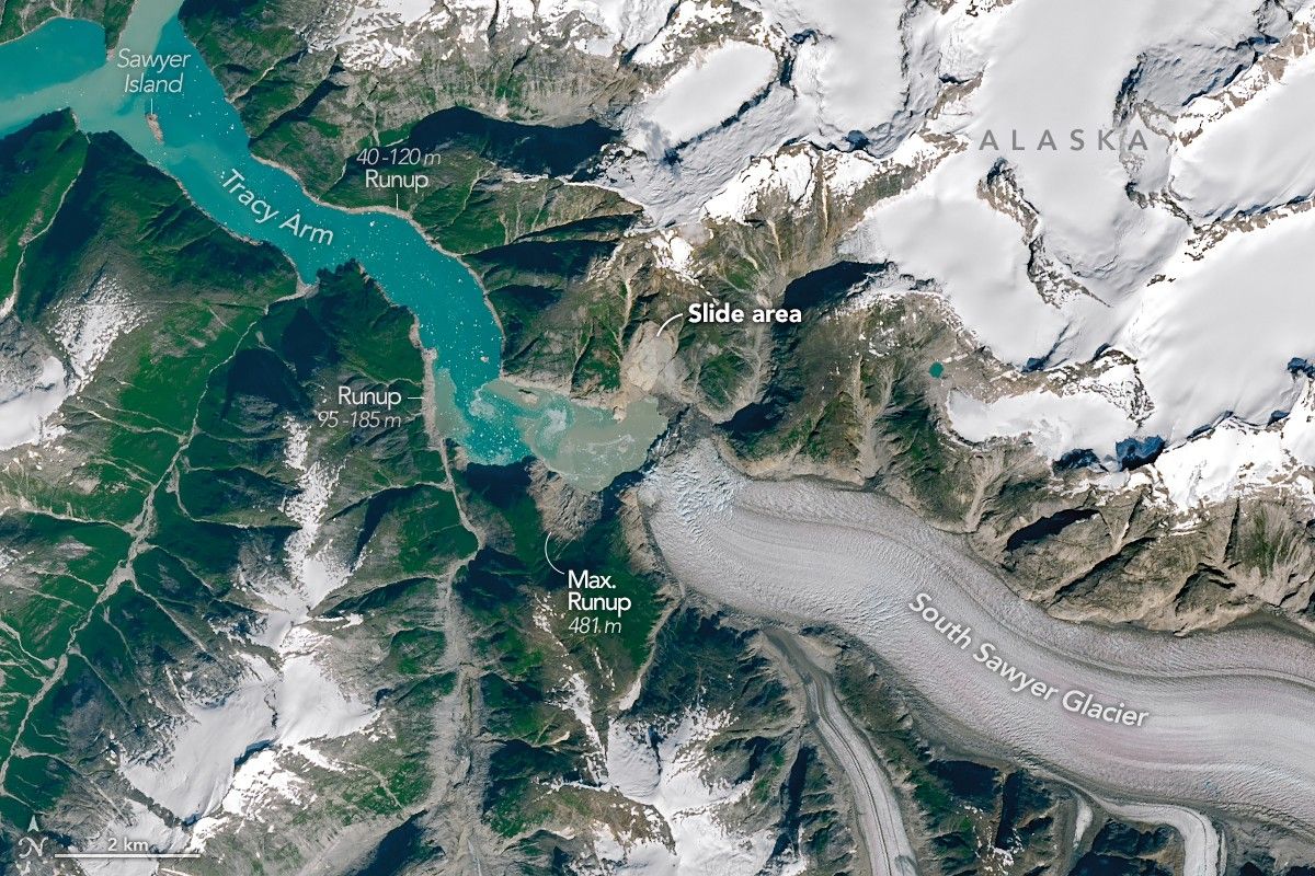
If we go back to last season, Episodes 9 and 10, the retreat of glaciers and hydrothermal alteration helped set the stage for Canada's largest recorded landslide at Mount Meager. The landslide we're discussing today has that glacier environment, but that's where the comparison starts to break down. The Tracy Arm landslide took place on August 10, 2025, when at least 0.065 cubic kilometers—or 65 million cubic meters, roughly 25,600 Olympic-sized swimming pools of rock and debris—collapsed into the fjord carved by the South Sawyer Glacier.
The debris displaced enough water to reach a 481-meter run-up on the opposite side of the fjord. 481 meters. That's a tsunami run-up higher than the Empire State Building in New York, or taller than Toronto's CN Tower observation deck. Thankfully, it happened in the early morning, no cruise ships were in the vicinity, and no one lives nearby, so no one was hurt.
All right, there's the setup. Now to get into the science instead of just the headline numbers. Joining the show is my colleague and fellow SFU alumni, Dr. Dan Shugar, whose PhD research focused on the interplay of landslides and glacial terrain. He's now an associate professor at the University of Calgary and is here to talk about the Tracy Arm landslide.
[Transition]
Dr. Jeffrey Zurek: It's my great pleasure to welcome Dan Shugar to Whimsical Wavelengths.
Dr. Dan Shugar: My pleasure to be here.
Dr. Jeffrey Zurek: Before we get to the science, let's talk about your journey. Part of the reason I do this is to show that there are usually twists and turns throughout a scientific career; it's rarely a linear path. I went snooping, Dan. Before your PhD and Master's, you were an editorial assistant for a geoscience publication. Is that what pushed you towards research?
Dr. Dan Shugar: Well, I was a newspaper reporter in England for a year—nothing to do with science. But I also worked as an editorial assistant at Canadian Geographic magazine in Ottawa during a co-op term in my undergrad. I really enjoyed being in that editorial headspace. I did a little research project for the editor at the time, and it was a really great experience doing something completely different from what a typical physical science student does.
Dr. Jeffrey Zurek: But that had no effect on whether or not you went for a Master's or a PhD?
Dr. Dan Shugar: Oh, no. I really enjoyed research. As an undergrad, I was super fortunate to go up to the central Yukon for two summers to work as a research assistant. I caught the bug—the desire to do research, but also a love of the North, which is just a magical place. At the time, I was pretty sure I wanted to work as a scientist for the Geological Survey of Canada (GSC). I remember seeing their movable library shelves and thinking, "This is the future right here."
But during my Master's, I came to the realization that if I wanted to be the scientist actually asking the questions, rather than just helping answer them, I needed a PhD. I couldn't fully satiate my curiosity with a Master's, at least not in a government context. One thing led to another, I ended up at SFU for my PhD, and eventually here at the University of Calgary. It's been an interesting journey.
Dr. Jeffrey Zurek: I think that's always the case in science. It's so weird and bureaucratic, but wonderful and magical at the same time. We spend 98% of our time at our desks. We come back from fieldwork and share photos, and people get a false sense that our job is tramping around in the mountains for nine months out of the year.
Dr. Dan Shugar: Yeah, you do that for a little bit, but I wouldn't trade it for almost anything, for sure.
Dr. Jeffrey Zurek: Let's get into the paper of today. We're recording in early September, and it will go live on October 12th. Right now, the news is dominated by the glacier collapse in Nepal, and I want to tie it all together eventually. But first, let's start with your recent article on the 481-meter high landslide tsunami in a cruise ship-frequented Alaska fjord: the Tracy Arm landslide. Where is Tracy Arm?
Dr. Dan Shugar: Tracy Arm is a fjord in Southeast Alaska, about 100 kilometers southeast of Juneau. It is a very bendy fjord that Slartibartfast would appreciate—hopefully some listeners will get that Hitchhiker's Guide reference. It has very steep sides, high relief, and a tidewater glacier up one of its branches. It's one of many fjords cruise ships travel up to look at the incredible scenery. And just over a year ago, last August 2025, there was a really big wave.
Dr. Jeffrey Zurek: What caused that very big wave?
Dr. Dan Shugar: When the average person thinks of a tsunami, they think of the 2004 Boxing Day tsunami or the 2011 Tohoku earthquake. Those are seismically triggered, traveling across oceans at jet speeds, running up to 20 or 30 meters on coastlines—which is, of course, catastrophic. But the biggest tsunamis in terms of run-up height tend to be triggered by landslides.
Think of doing a cannonball into a bathtub or swimming pool. You displace the water outwards, and when it hits the edges, it goes upwards. In a steep, narrow fjord, the water sloshes up the sides to dizzying heights. You get a huge volume of rock—tens of millions of cubic meters—crashing into the sea, and the water only has one way to go.
Dr. Jeffrey Zurek: My understanding is that no one actually witnessed it. So what was the first thing people noticed?
Dr. Dan Shugar: About half an hour after the event, a seismologist colleague of mine in Washington got a text from friends captaining a small charter boat in Endicott Arm, one fjord to the south. They experienced a big tsunami wave but felt no earthquake, and suspected a landslide. That was the first notification. We eventually figured out the location by analyzing the seismic squiggles, which look different for a landslide than an earthquake. The water also generated a seiche—a wave sloshing back and forth—which released seismic energy recorded around the world for 36 hours.
Because it was cloudy, it took a couple of days before we got a clear satellite image. When we did, the geometry was nearly identical to a similar event in Taan Fiord, Alaska, in 2015, which generated a nearly 200-meter tsunami.
Dr. Jeffrey Zurek: That sounds relatively common on a geologic timescale. Are these events accelerating due to slope stability problems? We have a process called "debuttressing," where the glacier used to press against the fjord walls supporting them, but now the ice has retreated.
Dr. Dan Shugar: That's a fair description. The term comes from the flying buttresses on ancient European cathedrals that keep walls from falling outward. In glaciated environments, glacier erosion steepens the mountainsides beyond what can self-support. When the glacier is removed—especially very quickly—those slopes fail. There's general agreement in the hazards community that debuttressing is a major factor, though the exact physics and rock mechanics still need more research.
Dr. Jeffrey Zurek: We don't really know how often these occurred in the recent geologic past, right?
Dr. Dan Shugar: Right. The Norwegians have extensive datasets on large rock slope failures going back thousands of years, many coinciding with past deglaciations. So there is a link with glacier retreat. But seeing into the rock beforehand is hard.
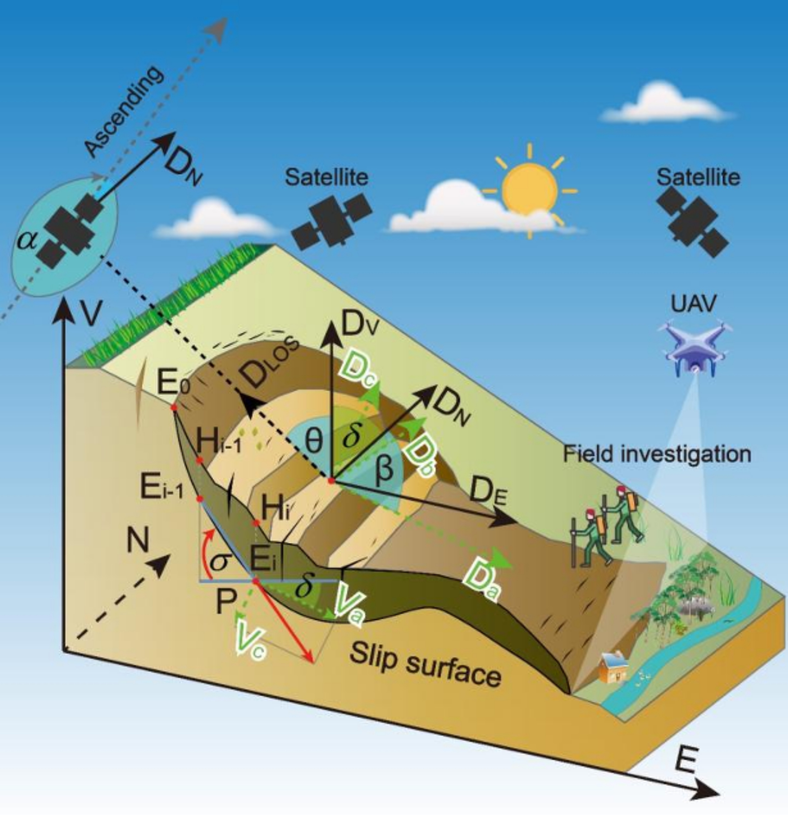
Dr. Jeffrey Zurek: How are these problem slopes identified then? I know InSAR (Interferometric Synthetic Aperture Radar) is used to detect movement, but glaciers are noisy environments for that data.
Dr. Dan Shugar: InSAR is incredible, but fast motion and surface melt on glaciers cause incoherence. Steep terrain causes shadowing and "layover" effects. However, a brand new joint US-Indian satellite called NISAR uses a different wavelength that allows us to detect ground motion even through some vegetation canopy. For the recent Nepal disaster, we’ve seen NISAR results showing motion on that bedrock slope in the months prior to its failure. LiDAR is another huge tool—it maps the terrain beneath the trees. European countries often have 100% LiDAR coverage acquired regularly, but in Canada, public access to LiDAR data is still far behind.
Dr. Jeffrey Zurek: Let's pivot to Nepal. Historically, disasters like the 1985 Nevado del Ruiz lahar in Colombia changed hazard mitigation forever by spurring the creation of volcano monitoring programs. Today, we're dealing with the aftermath of the massive flood in Nepal due to a glacier collapse. What actually happened there?
Dr. Dan Shugar: In today's 24-hour news cycle, the first videos showed a massive flood coming down steep Himalayan valleys. The immediate guess was a glacial lake outburst flood. But using Planet Labs satellite imagery, I traced the source up the valley to Langtang Lirung peak—the same mountain that generated the landslides during the 2015 Gorkha earthquake.
Initially, we only saw a missing section of glacier through the monsoon clouds. But 24 hours later, clearer imagery revealed a huge chunk of the mountainside had collapsed, taking the glacier with it. It was a rock and ice avalanche. What baffles us is the sheer volume of water. Like the Chamoli disaster in India a few years ago, the rock falling thousands of meters generates incredible heat, melting the entrained ice and snow almost instantly. But the water volumes we're seeing in the Nepal footage are staggering. Over a hundred scientists are on a Slack channel working night and day, and we're still searching for answers to how it got this big.
Dr. Jeffrey Zurek: There's been some pushback online about scientists racing to publish on disasters while the event is still fresh. How do you balance the human tragedy with the scientific process?
Dr. Dan Shugar: It's tough. We are still in the response phase. Right now, we are doing everything we can through backchannels to provide data that warns of secondary impacts or directs resources. But eventually, our day job is science, and publications are how policy gets influenced. The papers from the Chamoli event were used in Supreme Court cases to halt risky hydropower developments. We don't need to publish the very next day, but writing these papers contributes directly to mitigating future risks and developing early warning systems to save lives. It's a tremendous, horrific disaster. But the international scientific community banding together to help is a silver lining.
Dr. Jeffrey Zurek: I think scientists are more altruistic than we get credit for. We do it to understand and protect the future. Looking forward, what's the future for the field regarding hazard mitigation?
Dr. Dan Shugar: We're seeing country and continent-scale InSAR deformation portals coming online. Once we can process that data in near-real-time—combining it with machine learning and widespread LiDAR—we can automatically identify pixel clusters that are accelerating towards failure. That’s where the big leaps will happen in the next 5 to 10 years. Also, understanding these hazards in the Arctic is a critical new frontier as shipping, mining, and tourism increase in places like Nunavut and Greenland.
Dr. Jeffrey Zurek: Thank you for unpacking all of this. We usually end on a lighter note, but given the heavy subject, I think a self-deprecating geology joke is best.
Dr. Dan Shugar: I'll describe my favorite geology meme. Some years ago, the San Miguel Sheriff's Department in Colorado tweeted a photo of a snowy highway blocked by a rock. The caption read: "Large boulder the size of a small boulder is completely blocking eastbound lane Highway 145." I actually tried to sneak the phrase "large boulder the size of a small boulder" into a recent paper, but Reviewer Two rejected it.
Dr. Jeffrey Zurek: It's always Reviewer Two! Thank you so much, Dan, for being on Whimsical Wavelengths.
Dr. Dan Shugar: My pleasure.
Dr. Jeffrey Zurek: That's episode three, season three in the books. When a disaster happens in real-time, there’s a complex mix of emotions. You’re dealing with the science, but you're also dealing with a human tragedy. I really appreciate Dan coming on to explain both the science and the reality of the response. Remember to leave a rating, review, subscribe, and tell a friend. I'll see you in two weeks.
[Outro Music] Swaying to rhythms as the galaxies fly by. Who are tuned in feeling the beat of the unknown? Can you hear it? It echoes deep in our bones. Through this melodic maze our minds explore...