Episode Transcript
▼
[00:00:30] Dr. Jeffrey Zurek:
It's Whimsical Wavelengths, a science podcast, and I'm your host, Dr. Jeffrey Zurek. We're stepping back into my wheelhouse today into volcanology. We're going to explore eruption forecasting, machine learning, precursory activity, and how we know what we know.
But one first thing of a personal note, although this will be published after my upcoming surgery, if I sound a little different on the episode after this one, it very well could be because of that. Just a heads up, I have no idea what it's going to be like afterwards. There is a non-cancerous tumor being removed from my neck and we'll see how that all shakes out and happens. So if I sound a little different at the top of the next episode, that's the reason why.
[00:01:27] Dr. Jeffrey Zurek:
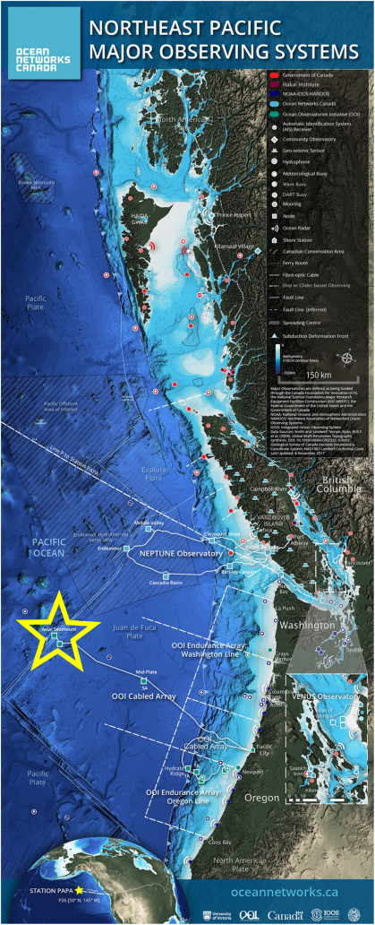
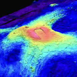
But today we're going to be talking about Axial Volcano. It's the site of our auditory field trip today. It's approximately 460 kilometers off the coast of Oregon. This volcano sits well beneath the waves, beneath the ocean, directly on top of the Juan de Fuca and Pacific Plate boundary.
Okay, well, most people don't exactly have a tectonic map in their heads ready to be brought up and rotated in three dimensions. If a picture is worth a thousand words, a built auditory map is worth... well, I'm pretty sure it's still a thousand words, but delivered entirely through the soothing tones of my voice. Quick public service announcement: if you're currently driving, please don't let the soothing explanation of the Juan de Fuca plate distract you from the vehicle in front of you.
[00:02:19] Dr. Jeffrey Zurek:
If we think of the coast of North America, from British Columbia, Canada, through Washington State, Oregon State, and into Northern California, this is the Cascadia subduction zone here. Small oceanic plates are being subducted or pushed beneath the North American plate. So the Pacific Ocean roughly maps out the Pacific Plate. It's an oceanic plate made from denser rock than the continents—basaltic in nature, mafic—so it displaces more of the mantle and sits lower, so the ocean sits on top of it.
Well, the Pacific Plate is moving northwest. And so, this is where it gets a bit more interesting. Due to this movement, the edges of tectonic plates, of the Pacific Plate more specifically, get quite a bit more complicated. In Southern California and Northern Mexico, part of North America is actually part of the Pacific Plate, the western side of the San Andreas Fault. North of the San Andreas Fault, the Pacific is continuing its northwestward direction away from North America.
[00:03:33] Dr. Jeffrey Zurek:
This region is where the Cascadia subduction zone begins, as small microplates—Gorda Plate, Juan de Fuca Plate, and the Explorer Plate—are subducting beneath North America. How all of this came to be, and the dramatic breakup of the Farallon Plate, is a story for another episode.
Axial Volcano sits at the intersection where the Pacific Plate is moving northwest and the Juan de Fuca Plate is moving southeast—a mid-ocean ridge. To top it all off, it is part of the Cobb-Eickelberg seamount chain, meaning it's also a hotspot. Hotspot volcano sitting right over an oceanic ridge. Like Iceland, but with fewer indie folk bands.
One last thing. Like Iceland volcanoes, Axial Volcano also erupts mafic lava or basalt, a lava with a low viscosity or is relatively easy to flow.
[00:04:34] Dr. Jeffrey Zurek:
Okay, now with all the background that I think we need to understand the discussion, it's time to bring in today's guest, Dr. Bill Chadwick, a geophysicist and researcher at Oregon State University. So it's my great pleasure to welcome Dr. Bill Chadwick to the podcast. Thanks for coming.
[00:04:53] Dr. Bill Chadwick:
Thanks, Jeff. Happy to be here. Thanks for inviting me.
[00:04:57] Dr. Jeffrey Zurek:
Yes. I love being able to get all the knowledge from all my guests, or at least try to, what I can absorb into this dense, thick skull of mine. But before we get to what I really want to ask questions about and really unpack and dig into, which is Axial Volcano, I thought maybe a question that goes down memory lane.
You graduated just after the fateful eruption of Mount St. Helens, something that captured the imagination of aspiring volcanologists for years, myself included, because I got to go and visit the area. I grew up in British Columbia, so it wasn't too much of a journey. So how did that eruption kind of affect your career path?
[00:05:35] Dr. Bill Chadwick:
In a major way. You know, I was a geology major at Colorado College and not really knowing what I would do with it after college. And yeah, so Mount St. Helens erupted between my junior and senior year, and it really got my attention. And through some contacts, I ended up volunteering with the USGS during my senior year over my Christmas vacation when they were shorthanded.
Before I knew it, I was flying in a helicopter into the crater and helping Don Swanson, who's a USGS scientist, with fieldwork. And it was just so thrilling. That really gave me the volcanology bug. And I haven't recovered since.
Yeah, so with that connection, after college, I worked with the USGS at the Cascades Volcano Observatory for a couple of years after graduating and loved it so much and went on to graduate school. And I've been trying to monitor and understand active volcanoes ever since. The young folks that showed up at Mount St. Helens early on, we called it the University of Mount St. Helens because it was really a learning experience for all of us. We were moths to a flame and really learned a lot from the experience of being there.
[00:07:12] Dr. Jeffrey Zurek:
You could probably make the argument that the University of Mount St. Helens is really what pushed volcanology into a modern science. I mean, just the plethora of new techniques and gadgets and like it all kind of really comes to a fore directly after Mount St. Helens, doesn't it?
[00:07:28] Dr. Bill Chadwick:
Yeah, I mean, that was a huge event, really influential. I think the whole field learned a lot just by how well documented it was and then all the activity afterwards that continued for several years. Yeah, it was a great natural laboratory. So it was one of those major events in volcanology where there was a lot of steps forward at the time for sure.
[00:07:57] Dr. Jeffrey Zurek:
But then somehow you made the jump from being able to interact with the volcano hands-on in helicopters to being in a boat hundreds of meters above it—like, well, how'd you make the jump from being able to interact with the volcano to only being able to see it from afar? And I'm talking about underwater volcanoes specifically. Right. So it was driven by your PhD, or there has to have been something that got you into it.
[00:08:26] Dr. Bill Chadwick:
It was a job! Yeah. So worked at Mount St. Helens, went to graduate school, did a project on using the data I helped collect at Mount St. Helens, kind of a modeling study. So I was still above sea level then. I had a postdoc for a year also with the USGS for a project in the Galapagos on Galapagos volcanoes that was on land also.
Then I was looking for a job, my next job. And I got hired with this NOAA project that was studying submarine volcanoes and hydrothermal vents. And yeah, so that was a complete change. And I, you know, had no experience working in the marine environment, but where I went to graduate school at UC Santa Barbara, there were a lot of people doing marine geology and oceanographic research. So just from attending seminars, I had a lot of exposure to mid-ocean ridge science and so forth. So I had a good background knowledge, I guess.
But it turned out to be kind of a great niche because I was able to apply what I'd learned on land to the marine environment. And at the time, there wasn't much crosstalk between on-land volcanology and marine volcanology. The people working in the two fields had come from totally different paths. So there wasn't much communication. So in a way, I was in a perfect place to bridge the two.
And I don't know, somehow the timing was just right to make it really a worthwhile thing. So my early experience at Mount St. Helens was measuring ground deformation and trying to see what it told us about the processes happening inside a volcano. And I've ended up trying to do the same thing in the marine environment for the same reason. That's how it all evolved.
[00:10:35] Dr. Jeffrey Zurek:
So I want to pivot over to the actual activity, but instead of looking underneath the waves, we're going to look subaerial. We're going to look still more on land because this happens more on land. We have much more interaction with volcanoes. There's lots of examples of fellow volcanologists putting out warnings or forecasts, and lots of times they've gotten it right. Lots of times they've gotten it wrong.
Why is it just so damn hard? I mean, I have my own opinions about it coming from the same background, but I'd like to hear from someone who was actually responsible for putting out some forecasts instead of just me being an armchair quarterback here.
[00:11:13] Dr. Bill Chadwick:
Yeah. You know, the short answer is that the Earth is complex, and we don't know as much as we'd like. And, you know, volcanoes are a situation where everything that matters is underground where you can't see it, and so you're having to use indirect methods to try to figure out what's happening.
Because eruptions initiate when magma is trying to get out from where it's stored underground onto the surface, whether it's effusively or explosively, a lot of forecasting is looking for signs that that is about to happen. And there's some volcanoes in some situations where the signs are pretty clear, where there's a big buildup in the activity and that you can measure, and it's dramatic and pretty clear something's going to happen soon, that kind of thing.
But there's lots of other times when that's not the case and things happen suddenly and we don't really know why. And that's just how the Earth is. Sometimes things are kind of complicated and we don't fully understand how things work or why—the reasons for those differences. But a lot of efforts in eruption forecasting are trying to find those cases where there are predictable patterns and trying to learn as much from them as possible and then how to apply those to other places.
[00:13:05] Dr. Jeffrey Zurek:
Yeah, for sure. I like to think of it a bit more like when we look at the atmosphere, we have so many different ways of looking at the atmosphere from temperature to pressure, and we're in the atmosphere being able to directly measure it. Whereas volcanoes, we don't know how much gas or volatiles are inside that magma, we don't know what pressures are involved, we are strictly inferring it from quite a ways away usually.
And data is everything. So without it you might as well be using a Ouija board. And of course in volcanology we do have data, we just don't have as much as we'd like to have. And I think back to like the great job HVO or the Hawaiian Volcano Observatory does with forecasting fountaining eruptions or episodes like recently and getting all that information to policy people. But Kilauea is wired up. They've got instruments everywhere. We don't have extensive monitoring systems on most volcanoes, let alone those that are underneath the ocean waves deep beneath.
And so what is available on Axial Volcano?
[00:14:11] Dr. Bill Chadwick:
Well, Axial Seamount is probably the one place in the world we do have pretty good data, and it's because there's a cabled observatory that's been deployed out there. So there's a cable that runs from Pacific City on the coast of Oregon all the way out to Axial Seamount, almost 500 kilometers. And then there's a network of instruments that are plugged into the cable that monitor the volcano.
This was all part of a big effort funded by the National Science Foundation called the Ocean Observatories Initiative